
Introduction: The strategic blindspot most companies accept
Despite organizations investing heavily in CRM systems, key strategic gaps persist in territory performance blindspots, misaligned resource allocation, expansion risks, and limited competitive intelligence. All because their CRM lacks geographic insight. Industry research shows that for every $1 invested in CRM, companies can generate up to $8.71 in additional sales revenue, and these returns grow even higher when geospatial capabilities are integrated. CRM integrating services that surface geographic context inside your CRM, enabling leaders to visualize territories, optimize coverage, and anticipate market shifts. In this blog, you’ll discover how map-enhanced CRM impacts decision-making, from boosting sales representative productivity to targeting expansion, competitive mapping, and spatial analytics for smarter growth.
What is CRM
Customer relationship management is the system of record that captures every sales touch, support ticket and account signal; it’s where pipeline, contacts and engagement live so your teams can act with context and cadence.
Why Geography Matters in CRM
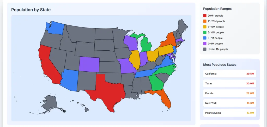
Adding location turns rows of customer data into a decision surface: you can visualise clusters, optimise routes, balance territories and spot nearby opportunities in minutes rather than quarters. Without geographic insight, companies might lose revenue from inefficient territory coverage, waste travel expenses and rep time on low-value routes, miss emergent market pockets and make poor strategic planning decisions that compound over time.
According to Forrester, after implementing a mobile CRM for field sales, USA Fact achieved a 90% user adoption rate and recorded a 12% increase in sales compared to the previous year.
What Are Interactive Maps in CRM Context?
Interactive maps in a CRM platform or CRM software bring spatial clarity to customer data making mountains of spreadsheets into intuitive visual insights. These maps use SVG graphics for sharp, scalable geographic precision. A few key capabilities:
- Data Visualization: Turn raw tables into actionable visual maps.
- Geospatial Filtering: Slice and dice customers, deals, and performance by location.
- Real-Time Updates: Fuse live CRM data for always-current market awareness.
- CRM Integration: Embed maps directly within your CRM for seamless workflows.
Why Interactive Maps Beat Traditional Dashboards
Static dashboards can’t keep pace with the speed and nuance of markets today. Interactive maps empower executives to:
- Instant Pattern Recognition: Spot regional trends in seconds.
- Strategic Territory Planning: Draw, adjust, and optimize outbound territories visually.
- Customer Density Analysis: Uncover high-saturation zones and untapped areas.
- Competitive Mapping: Overlay competitors’ presence for sharper strategic play.
- C-Suite Value: See your entire sales ecosystem on one screen from individual customer pins to high-level heat maps.
Strategic Capabilities You Gain from Geographic Intelligence
Leverage the strategic power of location-aware CRM for:
- Pattern Recognition: Pinpoint market shifts before competitors do and optimize routing via platforms
- Predictive Territory Planning: territory automation, design balanced territories proactively.
- Competitive Intelligence: Navigate market dynamics visually for smarter decisions.
- Strategic Decision Support: Contextual maps give clarity to every major choice letting teams turn CRM sheets into territory and performance heatmaps in minutes
- Trust Factor: The first time executives see their customer data mapped, they immediately spot 3–5 strategic opportunities they never considered.
CRM Integration Architecture
Explore the core architecture that connects your CRM with maps, ERP, and analytics for unified business intelligence.
What Gets Integrated?
Here are the CRM data points, geospatial layers, and third-party tools can be seamlessly connected.
- Customer Database
Address, contact details, interaction history all centralized in your crm software. When overlaid on maps, you immediately see customer clusters, high-value zones, and underserved areas. - Sales Pipeline
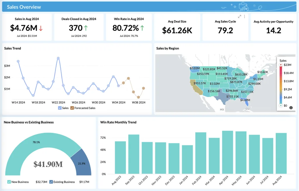
Visualize deals by stage and geography, your crm platform becomes a dynamic dashboard where pipeline stages map to regions. In fact, optimizing territory layout via mapping tools can increase sales by up to 7 percent and boost productivity by 10–20 percent. - Marketing Campaigns
Track campaign performance by region: click-through rates, conversions, even local sentiment all geospatially. This empowers targeted campaigns with real-time, location-aware feedback. - Support Tickets
Map service issues and ticket volumes across territories. By integrating your customer service management system with interactive maps, support teams can dispatch reps more efficiently, spotting hotspots at a glance. - External Data
Enrich your crm software by layering demographics, economic indicators, or competitor density. These overlays turn raw data into strategic, geographically informed decisions.
Integration Complexity Levels
The different levels of CRM integration complexity, from simple API links to enterprise-scale systems.
Level 1 – Basic Mapping:
We plot customer locations directly from your CRM, define clear territory boundaries, and enable instant filtering for quick insights. Executives gain location-aware visibility without disrupting existing workflows. This level meets the growing demand for real-time CRM geospatial integration that’s fast to deploy and secure.
Level 2 – Advanced Analytics:
We layer in heat maps, density analysis, and predictive territory modeling so leaders can spot sales opportunities before competitors do. Our integration overlays competitive intelligence onto your CRM, helping you forecast revenue, optimize territories, and improve field efficiency. Most mid-market companies report ROI within six months at this stage.
Level 3 – AI-Powered Intelligence:
We bring AI and machine learning into your CRM to dynamically rebalance territories, predict high-value customer locations, and guide acquisition strategies. We deliver unified, real-time, location-aware workflows combining predictive analytics, CRM intelligence, and geospatial data into one decision-making hub. Integrating tools like Azure Maps, we are adding advanced geospatial capabilities directly into CRM environments, empowering field sales and service operations.
Analytics Dashboard – Your Command Center
As an executive leader, you require one platform that unifies sales, customer, and market data, with instant location-based insights to make faster, data-driven decisions.
Executive Dashboard Components
- Performance Heat Maps: Instantly see revenue by region with intuitive color-coding for quick decision-making.
- Customer Density Layers: Track new customer acquisition trends as they emerge, not weeks later.
- Sales Rep Efficiency Metrics: Monitor performance by territory to spot high-impact and underperforming areas. More than 82 % of field sales representatives using mobile CRM report measurable improvements in data quality.
- Market Penetration Insights: Compare addressable market vs. actual coverage, layered with competitor footprint.
- Deal Stage & Issue Tracking: Drill into real-time deal status, bottlenecks, and resolution timelines.
Real-time Geospatial Filtering Capabilities
- Filter by Territory or Custom Boundaries: Pinpoint performance for any defined region.
- Time-Based Performance Analysis: Compare quarterly, monthly, or weekly trends to forecast with confidence.
- Customer Segment Filters: Focus on enterprise, mid-market, or SMB growth opportunities.
- Deal Probability Mapping: Visually prioritize deals most likely to close.
- Service Issue Hotspot Detection: Spot and resolve problem clusters before they hit retention.
An interactive, CRM-integrated analytics dashboard gives instant clarity, competitive context, and actionable next steps. And turns geospatial data into a strategic advantage.
Common Pitfalls and How to Avoid Them
Here are the top CRM integration mistakes and proven strategies to ensure smooth implementation.
- Data Quality Issues: Avoid inconsistent or poorly formatted addresses that cause mapping errors and inaccurate analytics. Standardize data entry and use automated address validation to maintain precision.
- Performance Problems: Large datasets can slow map rendering and frustrate users. Optimize queries, use data caching, and leverage scalable cloud infrastructure for smooth performance.
- Integration Complexity: Overlooking CRM API limits or system constraints leads to costly delays. Assess integration capabilities early and design with scalability in mind.
- Security Gaps: Geospatial data often contains sensitive business insights. Encrypt location data, enforce role-based access, and comply with relevant data protection regulations.
Real ERP Use Case: Interactive CRM Maps in Action
For one of India’s top insurance providers, we have implemented this in our ERP solution for three key reports:
- India Map View
- Click a state → See State wise data.
- Click a state → See State wise data.
- Region-Wise Map View
- Click a region → View all states in the region, with their respective data.
- Click a region → View all states in the region, with their respective data.
- State to City Drilldown
- Click a state → See breakdown of cities, with their details
- Click a state → See breakdown of cities, with their details
This helped managers:
- Spot underperforming areas instantly
- Prioritize sales visits based on revenue
- Make smarter territory decisions
Industry-Specific Applications
See how CRM and map integration delivers results across insurance, logistics, real estate, and more.
1. Retail & Consumer‑Packaged Goods (CPG)
Interactive CRM maps help Retail executives pinpoint high-value zones, personalized, micro-segmented campaigns, align promotional offers to local foot traffic, and improve inventory forecasts. Top Retail companies are now investing in omnichannel integration and AI-powered analytics to unify online-offline experiences
2. Financial Services, Banking & Insurance
CRM software that integrates geospatial overlays, like flood zones or fraud hotspots, into branch optimization, ATM network planning, and underwriting workflows are in demand in 2025. Predictive risk assessment and claims-management capabilities combined through CRM platform integration works best now.
3. Healthcare & Public Health
Geographic CRM visualizations of patient density, service deserts, or outbreak hotspots empower healthcare providers to allocate resources, site new clinics, or deploy emergency services where they’re most needed.
4. Logistics, Transportation & Supply Chain
Logistics and transportation companies are using the CRM platforms that integrate real-time routing, traffic analytics, and last-mile geospatial data to drive fleet and warehouse location decisions. They want integration in CRM software that aligns sales territories with logistics zones for more efficient delivery planning and resource utilization.
5. Real Estate & Commercial Property Development
CRM systems that plot demographics, amenities, and transit data to guide site valuation and investment decisions. They focus on geospatial overlays to assess walkability, infrastructure access, and market demand, backed by data-driven CRM integration.
6. Car Industry:
CRM-integrated telematics maps to understand usage-based insurance needs, regional service trends, and optimize dealer support. Mapping warranty claims and vehicle health data by region can reveal patterns that drive aftermarket services and targeted outreach.
7. Manufacturing & Industrial
Distributor network optimization and data-led field service routing. CRM geospatial tools help define optimal partner territories, improve response times, and inform expansion planning with precise geographic demand data.
Case Study: CRM Integration & Customer Management for an Insurance Leader
A top insurance provider in the extended vehicle warranty sector was struggling with fragmented systems, manual processes, and slow decision cycles. We built a CRM software with tightly integrated maps and custom Lead Management System (LMS) enabling:
- Integrated RTO vehicle information retrieval system, multi-stage approval processes and role-based access control
- Comprehensive dashboard system with evaluation, CPT, sales, accounts, and management metrics
- Automated policy renewal and document management
- WhatsApp integration for customer communications
- Advanced reporting capabilities with region-based access
- Advanced reporting & predictive analytics to track sales, renewals, and performance by region in real time
Within six months, they have achieved faster lead-to-policy conversion, increase in renewal rates, full visibility into sales performance across all business units and locations, and operational savings through reduced manual work and improved accuracy.
This maps and LMS integrated CRM platform gave leadership a single, AI-ready platform that unified sales, service, and analytics driving measurable revenue growth while strengthening customer satisfaction.
CRM Integration Services: Bluetick Consultants Inc
Bluetick Consultants Inc. delivers best-in-class tailored customer service management systems, CRM platform, and CRM software integration embedding interactive maps, AI-driven geospatial analytics, and mobile field routing. We’ve integrated with Microsoft Dynamics 365, HubSpot, Salesforce, Pipedrive, and Zoho across the US, India, and global markets. We know IT directors and business owners need geo-visual insights, smart mapping, real-time location analytics, and precision field routing, all seamlessly integrated in your CRM infrastructure. You’re looking for agile, data-driven CRM integration that turns raw customer data into strategic growth, and that’s exactly what we deliver.
FAQs
What is meant by CRM integration?
CRM integration is the process of connecting your CRM software with other business tools such as interactive maps, AI analytics, or ERP to create a unified customer service management system that drives efficiency and insights.
What are CRM integration services?
CRM integration services are expert solutions that embed tools like location intelligence, real-time mapping, and automated workflows into your CRM platform, ensuring data flows smoothly and supports smarter decision-making.
Can I integrate Google Maps into my CRM software?
Yes, using Google Maps APIs, you can embed location visualization, territory planning, and route optimization into CRM platforms like Dynamics 365, Salesforce, HubSpot, Pipedrive, and Zoho. This will turn your CRM into a location-intelligent growth engine..
Why is AI-driven CRM integration important for sales growth?
AI-powered CRM integration analyzes customer and sales location data to prioritize leads, optimize field visits, and uncover new markets, helping businesses in the US and India grow faster and smarter.
Turn Your Data into Advantage
An intelligent CRM isn’t just software, it’s competitive intelligence. While competitors run blind, your team will identify high-value territories, optimize field visits, and let AI-powered forecasts prioritize accounts most likely to close.
Talk to our experts and get a custom CRM integration that works exactly the way you need.